Umoona (Coober Pedy) and Ikara (Wilpena Pound)
Oct 2, 2023
Happy long weekend from Adelaide, on the traditional lands of the Kaurna people. We're in the final week of the big trip, which is exciting and weird and sad all at the same time. We've also had a bit of orthopedic drama in the last few days which has had thrown a bit of wrench into the plans for the final days of the adventure...

Nora and her greenstick fracture in her radius!
Our girl came off her bike in the caravan park in Streaky Bay, and for a while we thought it was just a sprain, but when it was still swollen 2 days later when we arrived in Adelaide we decided to get an X-ray just to be sure. Sure enough, there was a greenstick fracture 🤦♀️. At least we got it checked - now we just have to work out how to get her into a fracture clinic without having to go back through the ED.
And it must be said, while I have been extremely happy to copy much of the itinerary of the Gardiner's big trip for 2022, this was possibly taking it too far, given their middle child Reuben broke his arm in Adelaide during the final weeks of their trip. I really could have skipped this particular side-trip, thanks universe!
Anyways.... back to the adventures from earlier on the trip.

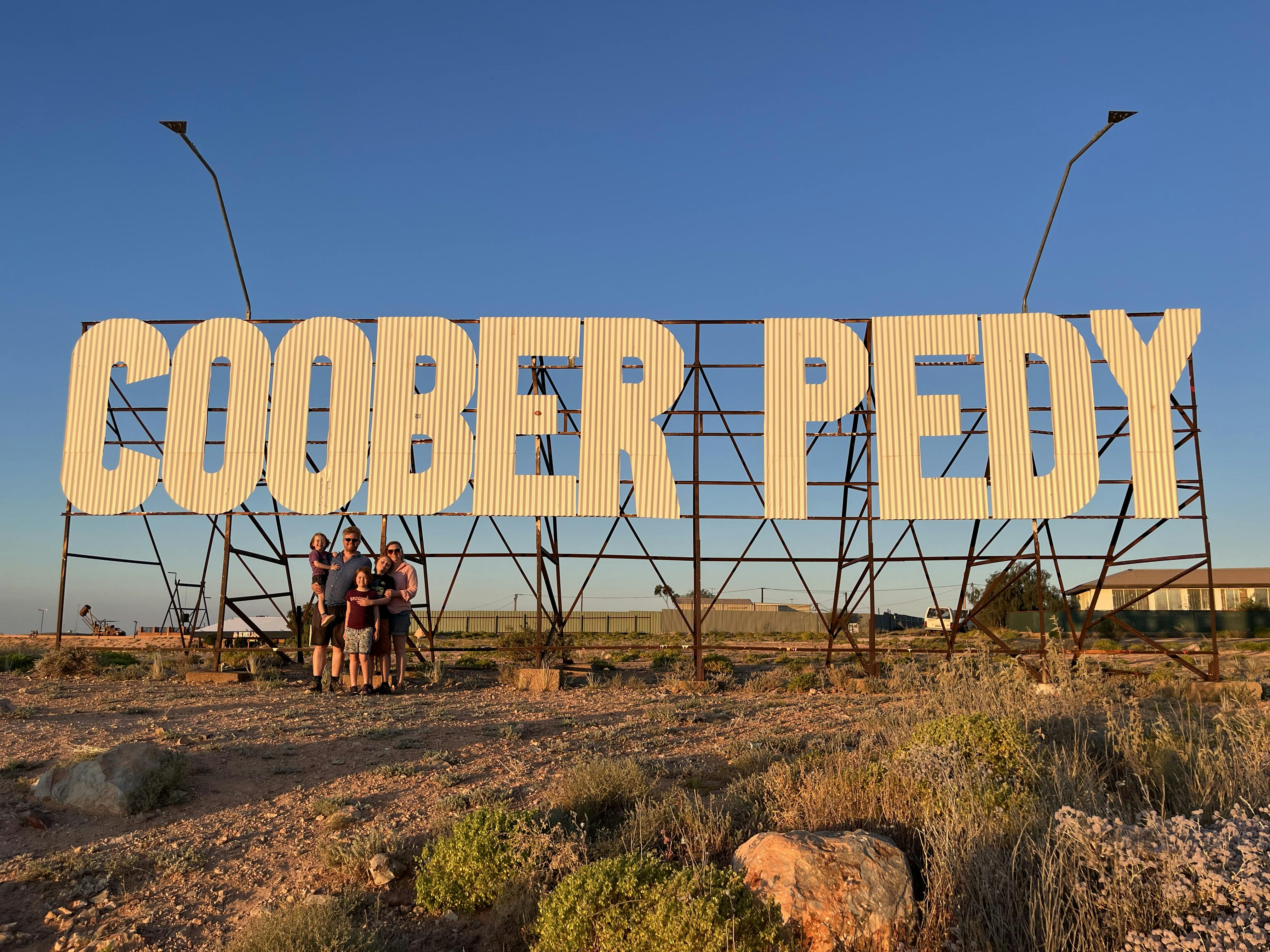
On Monday we left Central Australia, stopping in at the Erlunda roadhouse to have some lunch and meet some emus (see above) then saying goodbye to the Northern Territory which made me sad - we really loved our time there. We continued on the big drive down to Coober Pedy, for which the local Aboriginal people have adopted the name Umoona in recent years. We did also like the fact that the English name is thought to derive from the Kokatha-Parnkalla term kupa-piti, which means "whitefellas' hole", which made us laugh!
As most of you will know, Coober Pedy is a town based on opal mining. We learnt that Australia produces roughly 95% of the world's precious opal, and while the most valuable variety, the black opal, is found at Lightning Ridge in NSW, Coober Pedy is the largest producer of opals in the world by weight. And the particular spirit of the town is so shaped by the speculative, entrepreneurial and gung-ho nature of opal mining, it is definitely unlike any other town we have visited. Not going to lie, it is an odd town, but definitely worth a visit!
One of the key feature of the town is the amount of buildings and homes that are underground, both as a way to use the underground spaces left over from the mining, as well as a way of coping with the extreme heat in summer, given it the town is pretty much in the middle of the desert. We'd booked in to stay in a unit which had the kitchen and bathroom upstairs but that 2 bedrooms and lounge room underground, which was very cool (figuratively and literally!).

The kids' room, which did have a bit of a issue with bits of the ceiling plaster falling on the girls as they slept, but was still very cool!
The first full day in town was a big event, long anticipated - Josie turned 5! I was pretty emotional to see my baby officially become a big kid - god help me next year when she starts big school 😧😥

A 5 year old needs a 2 wheeled scooter!

I had done my research and made sure we'd been able to continue our tradition of birthday morning waffles - there was a very interesting shop called Waffles and Gems where an old German man sells opals and waffles. They were amazingly tasty. But it was a weird experience🤪😵
After our waffles we went to Tom's Working Opal Mine, as recommended by several people before and during our travels, which definitely lived up to the hype. The kids were so excited, having heard that they would get to mine their own opals. While 'mining' and 'opals' might be a bit of a stretch, they definitely got to find some rocks with colour or some amount of opal in them using using UV torches.


They were very excited by their haul....


The kids all got to try the bosun chair, which the miners use to get down the really big mine shafts

Like this one, which is 15 meters high /deep / long?!?!

They also got to try a blower which is a local invention from Coober Peddy that looks like this from above ground

Yup, like an old rusty truck with a big barrel hoisted up into the several metres above the ground - they were all over the town!

It was pretty dusty, and a bit cramped in spots, but very cool!

At the end of the tour, there were scones (delish!) and the opportunity for the kids to sell the 'opals' they found. I think the girls were a bit disappointed with what they were offered, so chose to keep the stones rather than accept the $1 and a lollipop. Toby took as it a challenge, drove a hard bargain and $2 and 3 lollipops!
In the evening we headed up to the Big Winch to watch the sunset over dinner, which was pretty special.

The 5 year old and the big winch...

and the sunset!

Me and my girls!
The next day we went fond a mini-golf course for Toby, which a local had set up in their 'backyard' during covid. It was fun, although the 'O' in opal was particularly tricky!


Love the poses!

Grrrrrr - thankfully there was a 7 stroke misery rule!

Then we drop in to the underground Serbian Orthodox Church, which was absolutely beautiful!


Dumps of discarded dirt from opal mines, which stretch for kilometres around the town, and are a clear sign to be careful of where you're stepping in case you fall down a mine.

Lengthening shadows as we wait for the sunset
On Thursday we headed south towards the Ikara-Flinders Ranges National Park, to stay at the Wilpena Pound Resort, known to the local Adnyamathanha people as Ikara (which means meeting place). On the way down we saw some amazing salt lakes - big wide white plains of salt as far as the eye can see.

A quick stop at Lake Hart

which is on the traditional lands of the Kokatha people
We arrived at the Wilpena Pound Resort and had a very early night - the long drives really do take it out of you. The Resort is in the Ikara-Flinders Ranger National Park which forms part of the traditional lands of the the Adnyamathanha people. In 2009 the Adnyamathanha, or rock people, were granted Native Title to around 41,000 square km of land running East from the edge of Lake Torrens, through the Northern Flinders Ranges approaching the South Australian border with New South Wales.
On Friday we drove over to the Old Wilpena Pound Station to see some of the evidence of early European presence in the area. As part of the national park the site is well preserved and attempts to tell the story of early European settlement, as well as the story of horrific effects this settlement had on the the traditional owners.

Some very old buildings, set against the majestic river red gums and the ranges of Wilpena Pound


The blacksmith's building


I was very excited to see a whole bunch of another purple flower, but was then VERY sad to hear it was a noxious weed known as Patterson's curse.

Reading about the building technique used in some of the original buildings, pug and pine, which is a form of wattle and daub originated in South Australia.

These trees were just phenomenal - some of them are thought to be 800 or 1000 years old, and up to 10 minutes wide at the base of the trunk.

A whole mob of emus, just wandering around!


We didn't get a photo but we also got to see a emu dad and his chicks!
In the evening Toby and Nora and I went on a sunset tour to Stokes Hill lookout to watch the sun set over Ikara (Wilpena Pound), which was gorgeous. Using a (bronze?) scale model, we learnt a bit more about the geological formation, which was called a pound after the old English term for a livestock enclosure usually surrounded by stone walls and is located in a semi-arid landscape, with very little rain (if any) most years. In the belief systems of the Adnyamathanha people tell of the creation of their traditional lands, in which spiritual snakes created the walls of Ikara - creation serpents are a common theme through so many of the stories we have heard on this trip.

This is the scale model - I asked Toby to take a photo of it but he wasn't quite able to capture it ....

So here is one I found on the internet. It was pretty cool 3D map!

A Toby panorama!

So many selfies at the golden hour!


The next day we did a 'time travel and gorgeous gorges' tour with Malcolm, which focused on the geological formation of the area. Here is my best attempt at relaying some of the key concepts, and while I'm doing as much due diligence as possible at 10:30 on a Sunday might, I definitely wouldn't quote anything I'm about to say!
The tour followed Brachina Gorge Geological Trail, which provides a geological record from period between about 800 million and 500 million years ago and offers an insight into 130 million years of Earth’s history. The ranges and gorges were formed through folding and buckling due to the movement of the tectonic plates around 500 million years ago and through this movement various layers of sedimentary rock were exposed, creating one of best sites in the world to view the evidence of the planet’s evolution. In particular, the rocks contain four separate types of fossils that represent a distinct stage of evolution of life, from single cell organisms to animals. All of this was pretty cool!
We got to see stromatolites, which are evidence of primitive single-celled microscopic organisms that lived in the sea and were responsible for gradually building up the oxygen content of the atmosphere (through photosynthesis) to a point that animal life was able to evolve. Unfortunately we didn't take any photos of them, and even the internet has failed me. They kinda just looked like dots in the stone - not the most impressive, visually, but very important nonetheless!
At our next stop we got to see a golden spike, technically known as a Global Boundary Stratotype Section and Point (GSSP), which is a reference point used to define the lower boundary of a stage on the geologic time scale. This golden spike indicates the start of the Ediacaran Period (around 600 million years ago) when the world transitioned from a planet that largely consisted of microscopic organism to one which was dominated by animals.

Just below Nora's knee you can see the golden spike where the change in colour in the rock, from red to lighter yellow, indicates the change in geological time periods. It's the only one in Australia!

All 3 kids at the spike!

Our guide told us is was solidified lava flow, which no-one really knows why it is here. But I can't find any evidence of it on the internet or in the pamphlet on the Geology of the Flinders Ranges National Park that I bought, so I'm not quite sure about it.... either way it looks cool!
Next we stopped next to a steep, rocky hillside where we got to see some andu, the Adnyamathanha name for the yellow-footed rock-wallaby. The wallabies are a vulnerable species, and had been completely wiped out of the Flinders Ranges by the 1980's. In the 90's there was a concerted effort to reintroduce zoo-bred animals back into the wild in the area which has been successful to date. It was very cool to see these fleet-footed cuties when we could spot them (they are very well camouflaged!), especially as they effortlessly bounded up the near vertical cliff face.

Here's where Bob's camera's zoom had another chance to shine!

We even got to see a young wallaby (but I think a bit bigger than a joey?), which you should be able to spot in the bottom left corner of the rock in this shot.
Our next stop was to see more fossils and other cool rock stuff (!), including fossils of very early animals.

Some of the fossils of the earliest animals, known collectively as the Ediacara Fauna.

And here is Nora pointing at a meteorite, because in amongst all the fossils and evidence of changes in the geological time periods, there is also space rock to be found!!

The kids take their place in history!

Close up so you can see Toby's serious explorer face / pose

Here's the view of Ikara from Razorback Lookout

In panorama

and with us included!
After the tour we went to the Welcome to Country that the resort hosts every afternoon/evening, and got to here some more creation / dreamtime stories from Terence, an Adnyamathanha man who works at the resort. He also told us about the meaning of the sybols in the flag that the Adnyamathanha people had adopted (pictured below). The blue represents the Ngiiarri (sky), the Brown the Yarta (land). The stars are two separate constellations - the saucepan (Orion), representing Mirarrityi (Men’s Muda) and the 7 sisters (Pleiades) representing Artinyi (Women’s Muda). The sun design is represents all Yura, the name the Adnyamathanha people use to describe themselves. The wavy line between the blue and the brown represents the rock ranges of the land.
We were very grateful to Terence for sharing these stories with us - as with so many Aboriginal people we have met on this trip, his generosity and grace was so impressive.

For the second time we did most of our packing the night before we left, and were almost on the road by 9 am which was very exciting. We really have gotten better at this whole process right as we near the end of the journey!!

On the way out we stopped at Hawker, where they have a Seismograph Station in the info centre / petrol station / convenience store that measures movement in the earth's crust due to movement in the tectonic plates. The large amount of movement that created the Flinders Ranges 500 million years ago created a fault line that runs from the ranges all the way down to Adelaide, and this seisograph shows that there continues to be persistent small earth tremors along the fault line today.

I can't pretend to know how to interpret the markings on this, but it was pretty cool to see!
Ok, that's me done for today / tonight. Might try again tomorrow to catch up on our time at Streaky Bay and here in lovely Adelaide. But no promises - we've got to pack for the journey home!