Tjoritja (West MacDonnell Ranges) and Mpulungkinya (Palm Valley)
Sep 10, 2023
Hello from the traditional lands of the Anangu people, in the shadow of the amazing Uluru. I'm a bit behind on the blog, so this post is going to be about our amazing 5 nights camping (!!) in and touring around the beautiful Tjoritja (known as the Western MacDonnell ranges) on the traditional the lands of the Western Arrente people. I'll try to get another post up soon covering our 3 days at Watarrka (Kings Canyon) and the start of our stay at Uluru - I'm trying to stay on top of this thing as it is making me get down the important memories before they get lost in the recesses of this brain of mine.
On Sunday we began our 'proper' camping expedition (although still at a campsite with hot showers and toilets - that's as hardcore as I get!!). We had purchased a bit more gear to try to make it as workable as possible, and the 'sunroom' (an enclosed gazebo thing that wasn't quite a whole other tent but pretty close!) was a big hit.

Here's our set up

Including an alfresco kitchen

The drive to the campground was 18 km of 4WD-ing, and despite very specific warning from Aunty Margie we still managed to lose a few eggs and a tub of tzatziki on the various trips in and out. It was pretty remote and as such reasonably quiet, but still always a few other caravans / camper trailers / roof top pop up tents keeping us company. We were just over the border of the Finke River National park, and had to drive through several different Aboriginal land trusts to reach it, where we sometimes saw wild horses that apparently the local community use for horse racing on occasion.


The sun setting on the rocks across the way from the campground

Bob particularly enjoyed the serenity while making his coffee, my tea and porridge for breakfast of a morning


I'm not sure of this will come through, but the stars were SO amazing that even my less than stellar (pun intended!) phone camera could capture them.
On Monday we drove the extra 4 kms of intense 4WD-ing to make it into Mpulungkinya (Palm Valley) proper. It's an amazing part of the world, with the English name reflecting the colony of Red Cabbage Palms found in the valley and surrounds, which is the only place it was found in Central Australia. For a long time scientists assumed that the palms were remnants of a prehistoric time when the climate supported tropical rainforest in what is now the arid inland of Australia. However more recent research proved that the palms are actually the same species as those found in Katherine and Mt Isa, both around 1,000 kms away. So the latest thinking is that the seeds may have been brought to Palm Valley by travelling Aboriginal communities and/or migrating birds.

Technically on the drive out, but as a good as an example of photographic evidence of the intensity of the 4WD-ing to get into the valley proper. There were slalom poles to keep us on the path as we did a rocky river crossing! Bob drove us in, and I got us out. Very exciting!

The walk in along the empty river bank, with huge towering sandstone cliffs overhead.

The first of the palms!

We cracked out the hat-based fly nets to try to keep the flies at bay - they are indeed intense!!

The valley was just so beautiful - the palms, the gum trees, the bird song. Just amazing.

After walking along the river bank we made the short climb to the ridge above the valley and made our way back along the same way, seeing the overview of the valley.

Walking along the ridge line - these little legs got a bit tired, but made it in the end. The camelbacks have been a HUGE success!


As I mentioned in my last post, I'm now totally obsessed with the wildflowers that are in bloom at the moment. To the extent that I will probably do a separate post just on wildflowers, so those of you who aren't so keen can skip it! But I have to share my first desert rose in the wild - I was VERY excited to see it.

Making our way back down from the top - we were very pleased to make it back to the car, and then to the campground for lunch and a quiet afternoon.
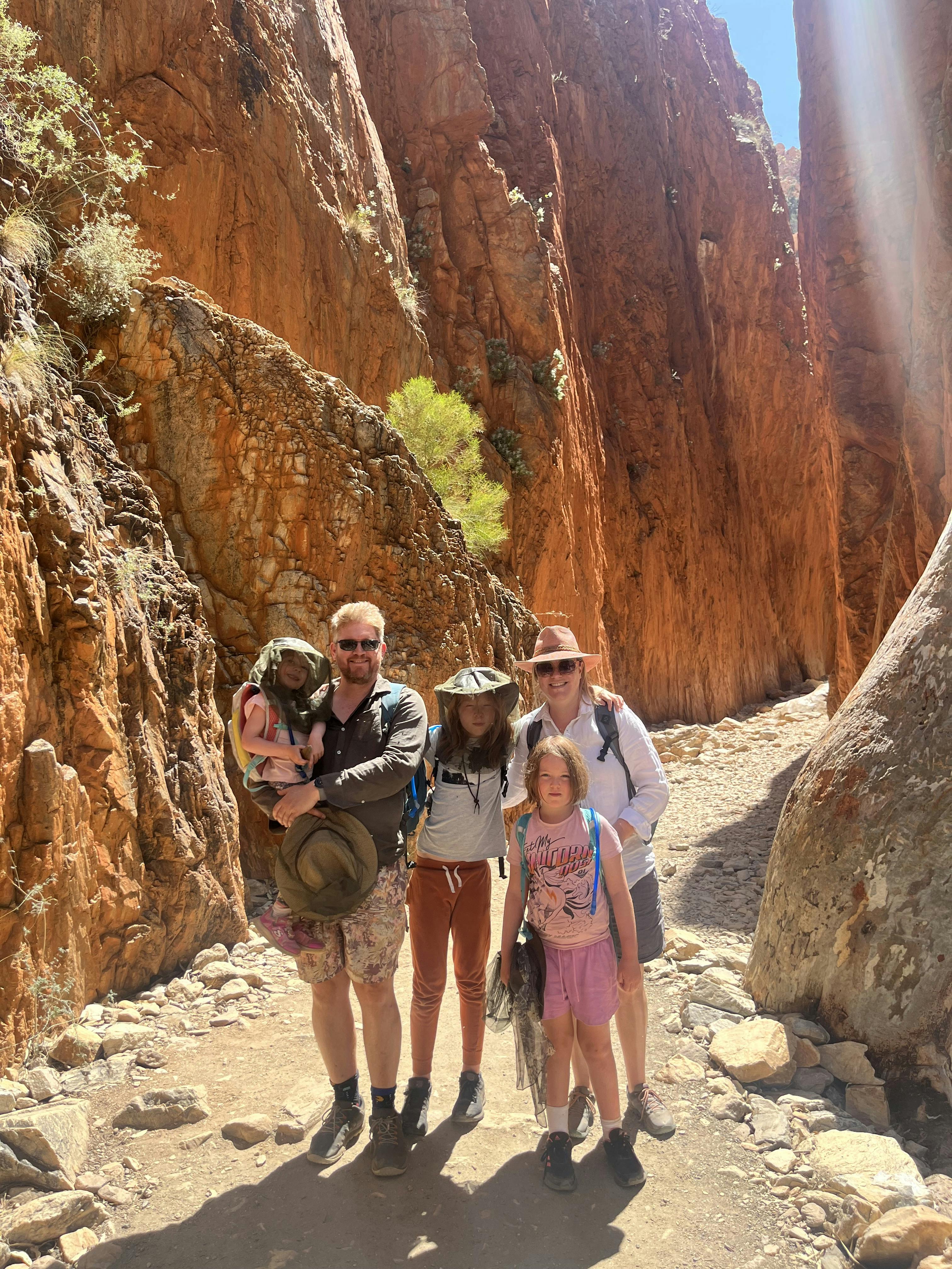
On Tuesday we headed to Angkerle Atwatye (which means Gap of Water, and is also known as Standley Chasm), the traditional land of the Western Arrente people and a sacred site of women's dreaming. Without doing our research we were still lucky to be there during the 90 minutes of the day where the sunlight makes it into the chasm. And it was just glorious.


The walk through a valley to get to the chasm.

The big kids looking into the chasm.


Looking back through the chasm.
We actually headed all the way back into Mparntwe (Alice Springs) after lunch at the kiosk, as we had to replace Josie's hat that unfortunately blew into the river on the first day at the campground. And while we were at the shop with the hats....

we bought matching Akubras!! Gerard would be proud ❤
On Wednesday we headed out from the valley to the West Macs via the Inner Mereenie Loop, going clockwise. We stopped at a look out where we could see Tnorala (Gosse Bluff) in the distance. Tnorala is an amazing geological feature, where an object from space crashed into the earth over 140 million years ago, leaving behind a crater that was about 20 km across. What is left today is 5 km across, and so is known as a remnant crater.

Unfortunately we were still a long way away from the crater, and the air quality was pretty terrible due to a bush fire somewhere in the area, so we didn't get a good photo of the crater. But I loved the creation story told on this info panel about the creation story of the Western Arrente people, in which a group of female creation spirits were dancing across the sky as the Milky Way. While the were dancing a mother put her baby in a wooden baby carrier which toppled over the edge of the dancing area and crashed into the earth, creating the circular rock walls of Tnorala.
Our first proper stop was Glen Helen Gorge - we had actually planned to stay at the caravan park there in the original itinerary, and still had it as a fall back if the camping endeavour hadn't worked out. Thankfully it didn't come to that as the park had to close due to issue with their water supply 😥. Unfortunately we had messed up our packing for the day and forgot the bag with the swimmers, so we just got to admire the view, and be a bit jealous of the bus load of other tourist who got to cool off after the walk in!


Next we headed to Orminston Gorge, where the lure of the beautiful water was just too much for us, swimmers be damned!

This waterhole is just so glorious - golden sand, majestic ghost gums, towering cliffs overhead.


I decided my knickers were pretty indistinguishable from a pair of bikini bottoms so got to paddle, which was delightful!

And Bob was lucky enough to be wearing board shorts, so he got to go all the way in!
Toby was happy enough just to put his feet in, and the girls started by taking off their pants, but eventually got down to knickers and a t-shirt and also got to go all the way into the water. It was just so lovely!!
On the way home we stopped to see Ochre Pits, an outcrop of ochre on the banks of a sandy creek. This ochre is an important part of of Aboriginal culture which is used in paintings and ceremonial body decoration. According to the NT tourism website, weapons were painted with ochre to increase the success of hunting and to protect wooden weapons from termites. Red ochre was mixed into an oinment to relieve congestion and white ochre is used as a magical charm.


On Thursday we headed into Ntaria (Hermannsburg) to visit the historic precinct. The precinct is the site of a Lutheran mission that was established in 1877, and was handed back to the local Western Arrente people in the 1980s. It's a complicated and complex place - as with all former missions, it is representative of many of the major crimes of colonisation, particularly in terms of the theft of traditional lands. However, the Hermannsburg Mission did take a different approach to many in that the traditional Arrente language wasn't suppressed as other languages were on other missions. In particular, one of the founding German Lutheran missionaries had a particular interest in and talent for languages so learned several Aboriginal languages and translated important bible verses into Arrente. I thought it was particularly lovely that the commemorative stone from 1896 above the door to the old church has a bible verse written three languages - English, German and Arrente.
There were also many attempts to establish industries at the mission to provide the local Aboriginal community with employment opportunities, including agriculture and a tannery. And perhaps most famously, there was a very strong focus on creativity and artistic endeavours at the mission, particularly the Hermannsburg School of Painting (embodied by the famous watercolours by Albert Namatjira), the Hermannsburg potters. And obviously there was a school room for the local Aboriginal children, where they were taught in English and Arrente. However, it was also hard to miss that there was a separate school room for the white children of the missionaries, which highlighted that even in a mission that supposedly took a more humanistic approach, there was still very strict segregation between the races right up into the 2nd half of the 20th century.

The kids had a lovely time exploring the precinct.

A connection to the old Bethlehem College at Ashfield - the church at the mission was called the Bethlehem Church.

The morning tea was so good we went back for lunch!
After a few hours in Hermannsburg we headed back to the campground to start the process of packing up camp. In the evening we were very lucky to who shared the campfire with a lovely group of travellers who had some of our roasted marshmallows in exchange for some very delicious fire-baked damper. We definitely got the better end of the deal!
On Friday morning we got up and finished packing up camp in some very fierce and chilly wind. We did pretty well, getting everything packed and ready to drive out by 10 am (it's still a slow process, especially when the tent is involved!!). Once we got back to the highway we had a big choice - do we head to Watarrka (Kings Canyon) by the safe conservative way, via Mparntwe (Alice Springs) which sticks to sealed highways the whole time but does take up to 7 hours? Or do we take the unsealed Mereenie Loop which is an unsealed dirt road but would get us there in 2 and a half hours? I was a bit nervous, but we asked at Ntaria (Hermannsburg) and some local had driven the loop road in the last week and said it was in pretty good condition. So we took the calculated risk and when the Mereenie Loop, which turned out to be perfectly fine! We were pretty chuffed - we felt very tough and rugged!

The Mereenie Loop Road heading to Watarrka.